| |
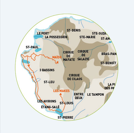
LES ARRÊTS ET POINTS DE VUE MARQUANTS
• Saint Gilles les hauts : ce village est en train de devenir une petite ville, empreinte d'histoire. En effet, dès le XVIIIe siècle, cette région était la propriété de la fameuse famille Panon Desbassyns.
• La Petite France : depuis le XVIIIe siècle, des agriculteurs cultivent le géranium rosat, entre autres, afin d'en tirer des huiles essentielles réputées. C'est un village créole.
• Le Piton Maïdo et le cirque de Mafate : ce point de vue « aérien », à 2200 m d'altitude, donne une vision exceptionnelle du bijou de notre île, le cirque de Mafate, sanctuaire des marrons (esclaves en fuite) et maintenant paradis des marcheurs.
• La Chapelle Pointue : sur le domaine du Musée de Villèle, cette petite chapelle du XIXe siècle renferme une partie de l'histoire de Saint Gilles les hauts.
• Route des Tamarins : cette autoroute rescente, vous offrira un belvédère sur la côte ouest et son lagon.
• Saint Louis : cette commune, qui abrite l'usine sucrière et l'étang du Gol, est une commune agricole, de la plaine côtière à la plaine de Bois de Nèfle à plus de 1000m d'altitude.
• La Fenêtre des Makes : c'est au bout de la route forestière que vous découvrirez un point de vue exceptionnel sur le cirque de Cilaos, ses remparts et sommets, dont le Piton des Neiges.
• Les Makes : ce village créole tire son nom des lémuriens de Madagascar, les Maki Vari, introduits et disparus au XIXe siècle. Ce village de tradition serait notre étape restauration.
• Étang Salé : notre promenade dans cette commune ira du village des hauts par la forêt domaniale. Puis le village de pêcheurs et sa magnifique plage de sable noir. Sans oublier le Gouffre, si la houle est présente...
• Le Souffleur : les vagues frappent la côte...et à cet endroit encore la compression crée un phénomène de geyser.
• La Pointe au sel : ce petit coin de côte au sud de Saint Leu est le lieu restant pour la production de sel marin.
• Saint Leu : c'est, encore une fois, une commune qui s'étend du « battant des lames au sommet des montagnes », et dont l'histoire est très riche. Ce fût la culture du café Bourbon, et aujourd'hui pour une partie de ce village créole, c'est parapente et surf, au niveau mondial!
|
|
STOPOVERS AND SCENIC SITES
• Saint-Gilles-Les Hauts (Saint Giles on the heights): A village steeped in history, fast growing into a small town. In the eighteenth century the area was the property of the famous Panon Desbassyns family.
• La Petite France: since the eighteenth century local farmers here grow geranium rosat, amongst others, and distil the famous essential oils. The place is listed as a Creole village.
• Piton Maïdo and the cirque of Mafate: Situated at an altitude of 2000 meters this "aerial" viewpoint gives an exceptional view of the jewel of our island, the cirque of Mafate, the one-time refuge of the "marrons" (escaped slaves) and today a hikers' paradise .
• La Chapelle Pointue (the pointed chapel): situated on the estate of the Musée de Villèle this small nineteenth century chapel is part of the history of Saint Gilles les Hauts.
• Route des Tamarins: this recent highway offers a panoramic view over the West coast and its lagoon.
• Saint Louis: agricultural community situated between the coastal plain to the plain of Bois de Nèfles (at 1000m of altitude). Also home to the Gol sugar mill and its lake.
• La Fenêtre des Makes (the window of the Makes): travel to the end of the forest road to get an exceptional view of the cirque of Cilaos surrounded by high cliffs and peaks, including the Piton des Neiges.
• The Makes: this Creole village takes its name from the Malagasy lemurs, Maki Vari. They were introduced to the island but became extinct during the nineteenth century. Lunch in the historic village.
• Étang Salé: our stroll through this community starts on the heights and leads through the national forest. Then on to the fishermen's village with its magnificent black sandy beach and if there is a heavy swell, we stop at the Gouffre (the abyss).
• Le Souffleur: (The Blower) the waves hit the coastline and at this particular spot the pressure creates a geyser phenomenon.
• La Pointe au Sel: (The Salt Point) this small spot on the coast south of Saint Leu is the only remaining salt works of the island.
• Saint Leu: once more a village rich in history that stretches from "the pounding waves to the mountain peaks". Once the region of "Bourbon" coffee growing, the Creole Village is today famous for paragliding and surfing at world class level.
|
|